GeoAI becomes valuable when the system can reason about where things are, how those locations relate, and how those relationships change the decision.
Emergency operations already depend on geospatial analysis: affected area, proximity, route, coverage, exposure, access and overlap. Traditional GIS is powerful, but users often need specialist knowledge to formulate the right query. Generative AI creates an opportunity to make spatial reasoning more accessible—provided the geometry remains governed and the answer remains explainable.
Language alone is not spatial reasoning
A model may understand the phrase “inside the evacuation area”, but the truth of that statement depends on coordinates, geometry, reference systems and the correct version of the evacuation boundary. The language model should not infer the answer from place names when a spatial computation is available.
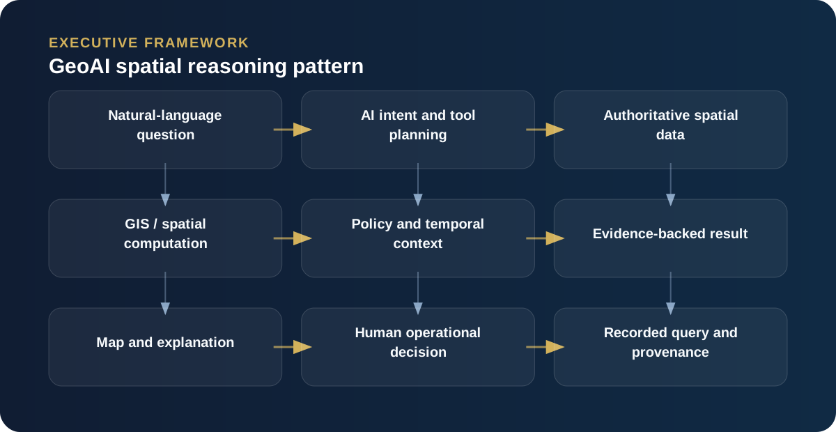
A robust GeoAI pattern uses the LLM to interpret the question and orchestrate tools, while spatial services perform the deterministic geometry operations.
Turn natural-language questions into governed spatial operations
A user might ask: “Which aged-care facilities are inside the current flood warning and more than twenty minutes from an open relief centre?” The AI should decompose this into source selection and spatial/network operations: retrieve the active warning geometry, retrieve facility locations, calculate intersection, retrieve relief centres, apply road-network travel time and present the results with sources.
The model helps orchestrate. It should not invent the geometry.
GeoAI needs semantic context
Spatial data often contains technically correct features that have unclear business meaning. Is this polygon a warning area, an observed impact area, a planning zone or a service boundary? Can it be used for eligibility? Is it current?
AI-ready geospatial ecosystems need metadata that describes meaning, authority, time, quality and permitted use. Recent OGC work on interoperable, AI-ready geospatial data is important because it treats interoperability and machine-readiness as ecosystem problems rather than model problems.
Use spatial reasoning to connect systems that were never designed together
One of the most useful properties of geography is that it creates relationships without shared business keys. An incident, property, warning, road closure, hospital, service provider and applicant can all be related through location.
That means GeoAI can provide an integration lens across fragmented operational systems. It can answer “what is affected?” even when no single source system contains that relationship.
Keep the evidence visible
A GeoAI answer should show the map layer or boundary used, effective time, feature identifiers and calculation performed. If a user asks why a case was considered outside an impacted area, the system should be able to display the tested location and relevant polygon, not just a textual explanation.
High-value GeoAI patterns
- Natural-language access to governed spatial queries.
- Automated exposure analysis for assets and communities.
- Spatial clustering of incidents or service demand.
- Route and accessibility analysis under changing conditions.
- Cross-source correlation using location and time.
- Map-based evidence preparation for case officers and commanders.
The architecture pattern
The LLM or agent handles intent, orchestration and explanation. A geospatial service handles geometry and network analysis. A metadata layer describes the meaning and authority of spatial datasets. A policy layer decides which outputs can support which business decisions. Telemetry records the query and evidence.
That combination gives organisations the conversational accessibility of AI without sacrificing the determinism and inspectability of GIS.
Let the language model orchestrate; let GIS compute
GeoAI becomes compelling when natural-language reasoning can invoke reliable spatial services. A user might ask which vulnerable facilities fall within a predicted impact zone, which evacuation routes intersect closures, or which assistance applications are outside the declared area. The language model can decompose the question, identify the required layers and explain the result. Spatial predicates, routing and raster/vector analysis should be executed by deterministic geospatial engines.
This pattern gives the organisation the best properties of both technologies: flexible interaction and contextual reasoning from AI; numerical and geometric rigour from GIS. It also makes testing much more practical because the spatial calculation can be validated independently of the language layer.
Metadata is operational safety
Every geospatial result should carry enough context to answer: which dataset, which version, what time, what coordinate reference system, what resolution, who owns it and how fresh is it? In emergency operations those details are not academic. A flood extent from six hours ago and one updated five minutes ago may lead to different decisions. AI should surface that uncertainty, not smooth it away.
Build reusable spatial tools, not bespoke prompts
The scalable approach is to expose governed capabilities such as geocode address, test containment, calculate distance, find intersection, retrieve features in area and route around restrictions. Agents can combine those tools for different operational questions. Security and data policy can then be applied at the tool and dataset level rather than relying on prompt discipline.