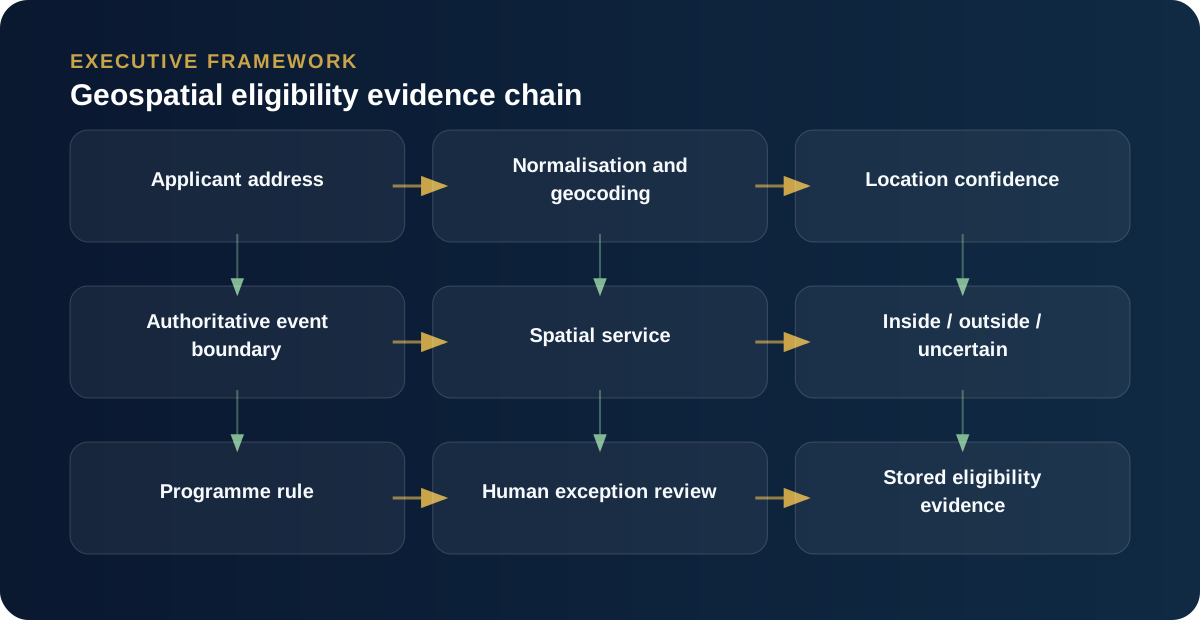
When location determines eligibility, the map is only one part of the control. The organisation must be able to explain which address was tested, against which boundary, at what version and time, using which spatial method, and what happened when the result was uncertain.
This becomes important in emergency assistance, grants, environmental regulation, service coverage and asset management. A coloured polygon on a screen can create false confidence if the underlying address or boundary is wrong.
Separate the business question from the spatial operation
The business question might be: “Was the applicant’s impacted residential address inside the declared area for this event and programme?” The spatial operation might be: “Does this geocoded point intersect this polygon?” Those are not the same statement.
The business question contains temporal rules, address type, programme rules and evidence requirements. The spatial service should answer the geometry question reliably; the case process should apply the business rule.
Address quality is often the weakest link
Before evaluating a polygon, the platform needs a trustworthy location. Free-text addresses can be incomplete, duplicated or geocoded to a suburb centroid rather than a property. Rural addresses, new developments and emergency locations create additional ambiguity.
A robust design records the original address, the normalised address, the geocoding source, coordinate precision and any confidence indicator. Low-quality matches should route to review rather than silently becoming precise coordinates.
Boundaries need lifecycle management
Emergency impact areas change. A warning may be updated, replaced or cancelled. A programme may use a declared area that is not identical to the public warning polygon. If the case system simply stores the latest polygon, it may become impossible to reconstruct why an earlier application was considered inside or outside the area.
The safer design stores the authoritative boundary identifier, source, version or effective time and the geometry used for the assessment. The eligibility result should reference that immutable evidence.
Standards such as the OASIS Common Alerting Protocol are useful because they provide a structured way to exchange alerts and can carry area information including polygons. The case platform still needs to decide which alerts are relevant, which geometries are suitable for eligibility and how changes are governed.
Make the spatial service independently testable
I prefer to keep spatial calculation behind a clear service boundary. The CRM or application sends a normalised location and the applicable boundary identifier; the spatial service returns inside/outside/uncertain plus evidence. This allows GIS logic, coordinate systems, geometry validation and performance to be tested independently from the case UI.
It also makes it easier to change mapping technology without redesigning the business process.
Design for the edge cases
- An address falls exactly on the polygon boundary.
- The applicant provides a postal address rather than the impacted property.
- The warning polygon changes after the application is submitted.
- A multi-unit property geocodes to a shared entrance.
- The geometry is invalid or self-intersecting.
- The geocoder returns a low-confidence suburb-level point.
If the system has no explicit answer for these cases, the “automated eligibility” claim is overstated.
The control should produce evidence, not just a boolean
A defensible result is not simply true or false. It should include the tested point, boundary identifier, source, timestamp, method, result, confidence or exception status, and any human override with reason.
That turns geospatial logic from a visual feature into a business control that can be explained to an applicant, auditor or decision-maker.
The polygon is only one part of the evidence chain
A point-in-polygon query can be technically correct and still produce the wrong business outcome. The address may have been geocoded to a suburb centroid. The emergency boundary may have changed after the application was lodged. A property may span a boundary. The source incident may have been superseded. Or the eligibility policy may refer to an impacted residence while the system is checking a postal address. Each of those is a business-control issue expressed through geospatial data.
I therefore treat spatial eligibility as a chain of evidence: authoritative event or incident; versioned impact geometry; applicant address and geocoding method; timestamp; spatial relationship; policy rule; result; and any human override with reason. That chain makes a later review possible. It also exposes where uncertainty exists rather than hiding it behind a green map marker.
Design explicitly for boundary change
Emergency information is dynamic. A warning area can expand, contract or be replaced. The case system needs to know whether eligibility should use the boundary that existed at time of impact, application, assessment or payment. That is a policy decision, not a GIS implementation detail. Once agreed, the data model should retain the appropriate boundary version or sufficient provenance to reconstruct the decision.
Use deterministic spatial computation, then add AI around it
AI can help users find the right incident, interpret unstructured descriptions, explain why a case was flagged or prioritise records that need review. The actual spatial predicate should remain deterministic and testable. This separation is important: probabilistic reasoning is useful around ambiguous evidence, while geometry operations such as contains, intersects and distance should be performed by geospatial engines designed for them. The result is both more powerful and easier to assure.